Services
Software Development and Integration
Creating software tools to understand and optimise business processes by:
- Integration of GIS technology into existing information systems and business processes
- Development of GIS and mapping software
- Building customised mapping applications
- Internet GIS and database applications
Data Processing
Management of data is a difficult issue. Integrated Mapping has considerable experience in
- data collection
- analysis and delivery of data via internet technologies
- visualisation of data
- preparing datasets for use in GIS applications
- converting data between different formats or coordinate systems
- data scrubbing
- geocoding & geo-referencing of databases, such as customer records
Our approach is to select technology appropriate to the task in hand, with the focus being on the outcome.
For Example...
Here are a couple of projects we've done:
SkyRanger
Wildtech NZ build systems for tracking endangered wildlife. They needed a custom mapping application to plan survey flights and to manage and report the collected data.
The SkyRanger application that we built presents the wildlife data dashboard, with the targets shown over a map background, with links to the associated attribute information. There are point-and-click for flight planning and export to the aircraft systems. Drag-and-drop tools left you sort and filter the results for analysis and reporting.
Portobello - Publishing Scientific Data
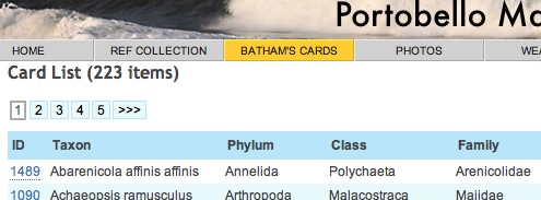
The Portobello Marine Laboratory of the University of Otago has been collecting science data since 1904. The Laboratory wanted to provide a way to make this data readily available.
As with any project involving data collected over a long period of time, there was an extensive process if data clean-up, digitising of paper records and geo-coding. The MarineInfo website that we developed provides a centralised location to maintain and distribute collection, climate and publication information. Once the geocoding process is completed it will also include online mapping.
Visual Dispatch
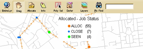
Integrated Mapping developed Visual Dispatch for 90/20 Technologies. This is a powerful map-based tool for managing job allocation and workflow for field staff. The map-based approach allows efficient allocation of work, minising wasted travel time and vehicle costs. It also allows low priority work to be slotted in on the way to scheduled work.
The implementation for dog control at the Christchurch City Council resulted in major cost savings and won an ALGIM Innovation Award.